Fugro USA Marine on behalf of New England Aqua Ventus will be conducting a Geophysical and Geotechnical seabed survey from East Boothbay to Monhegan.
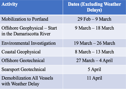
The seabed survey will be taking place March 8th through April 4th weather permitting. The survey will run west to east, beginning in the nearshore waters of the Damariscotta River and ending offshore south of Monhegan. Fishermen will need to remove gear from the path of the survey vessels, in the area marked in purple on the chart below.
If Fugro encounters gear, they will record:
- date, time, location, and water depth
- new location if gear was inadvertently dragged
- description of gear (gear type, tag number, buoy color)
- damage to the gear, survey vessel, or equipment
- photo documentation
If gear becomes entangled in survey vessel or equipment, Fugro will contact Marine Patrol to notify them that gear is being taken aboard, and it will be turned over to Marine Patrol at the earliest possible opportunity. If the gear contains identifying information, Marine Patrol will contact the license holder. There is a compensation program in the event of lost gear.
A chart of the complete cable route will be sent to Zones D and E license holders at their mailing address. Daily updates of the anticipated vessel locations will be issued via e-mail. Updates will also be available on the NEAV website: https://newenglandaquaventus.com/

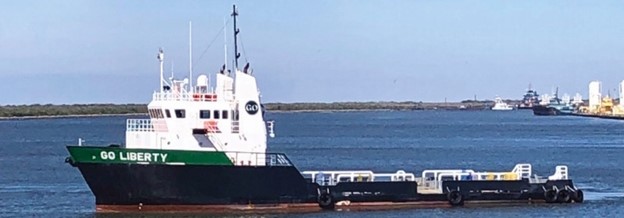
There will be three vessels conducting the work required for the survey. The R/V Westerly will be operating nearshore during daylight hours. The M/V Go Liberty and M/V Fugro Explorer will be operating offshore 24 hours a day. All operations are weather permitting.
Contact Fugro Vessels: VHF Ch. 16
R/V Westerly
Call Sign: WDF7918
Vessel Master: 805 850 9593
Email: rdbraget@gmail.com
M/V Go Liberty
Call Sign:WDK6648
Vessel Master: 337 446 5346
Email: goliberty@guiceoffshore.com
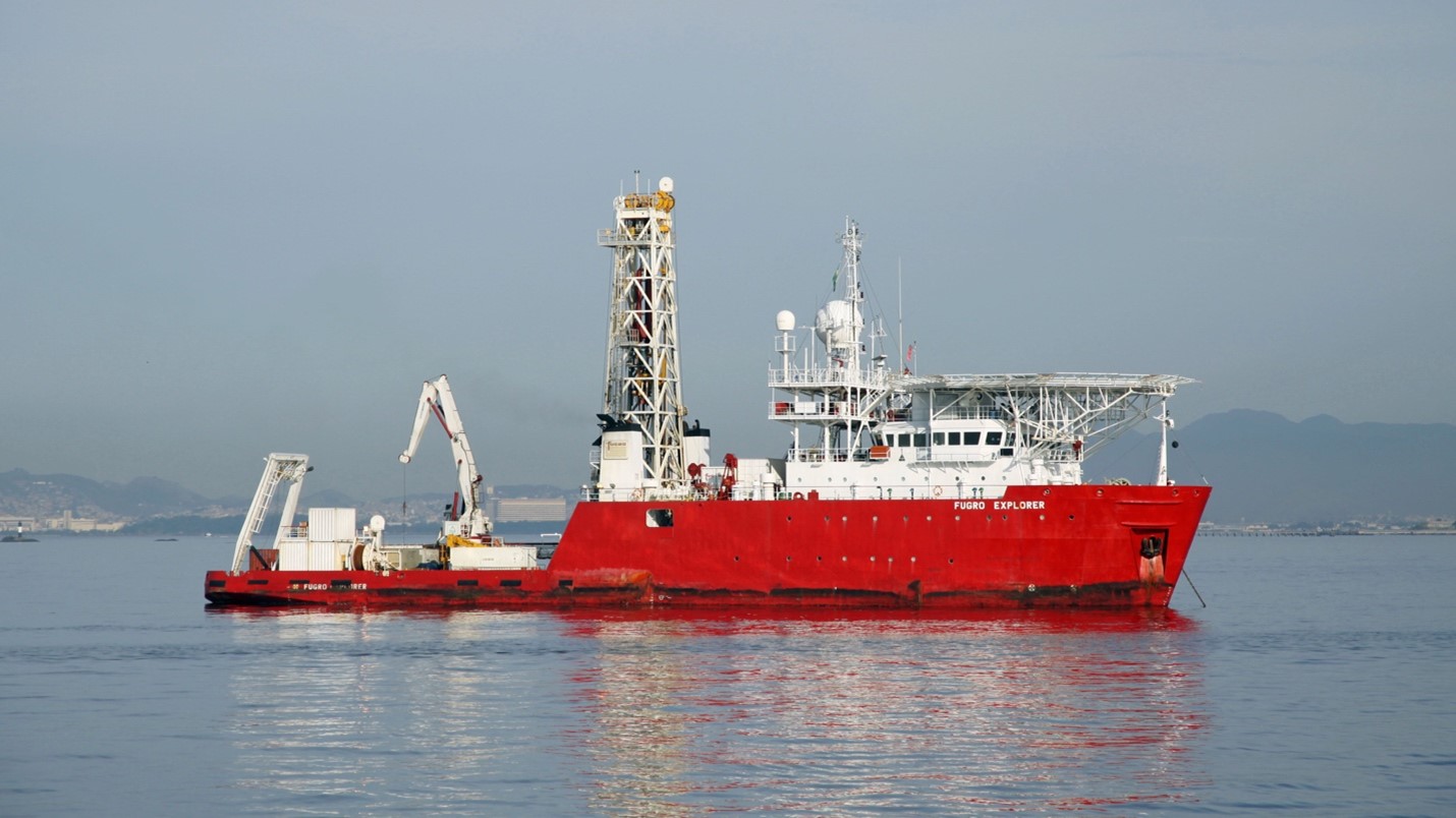
M/V Fugro Explorer
Call Sign: M/V Fugro Explorer/3FEV9
Vessel Master: 713 369 4472
Email: bridge@epr.fugro.com
Contact New England Aqua Ventus:
Duncan McEachern
254 Commercial Street, Suite 245
Portland Maine, 04101
207 523 3457
Email: info@dowdev.com
R/V Westerly will be operating multibeam bathymetry; side scan sonar; marine magnetometer; high frequency sub-bottom profilers; core sampling; and bottom photography to map the seafloor. Average vessel speed will be 3.5 knots when conducting survey, with towed sensors up to 200-feet behind vessel. Maximum vessel speed is 10 knots during transits when not towing equipment. The requested safety zone around the vessel while working is 1 nm. and is at the discretion of the Captain.
R/V Westerly will also transit to Mack Point, Searsport, and perform a geophysical survey east of the Bulk Pier. There is no requirement to move gear for this transit or survey work. It is anticipated that this work will occur during a weather delay day and not extend the overall schedule.

M/V Go Liberty will be operating multibeam bathymetry; side scan sonar; marine magnetometer; high frequency sub-bottom profilers; core sampling; and bottom photography to map the seafloor. Average vessel speed will be 3.5 knots with towed sensors up to 500-feet behind vessel, maximum vessel speed is 10 knots during transits when not towing equipment. The requested safety zone around the vessel while working is 1nm. and is at the discretion of the Captain.
M/V Fugro Explorer will be performing a geotechnical investigation at the test site where the permanent and temporary moorings will be located, as well as along the proposed cable route where sand and/or mud is found during the geophysical investigation. The cone penetration test (CPT) equipment and the vibracore equipment are deployed to the seafloor to collect soil property data. The M/V Fugro Explorer is a DP2 vessel and the vessel will be stationary while tests are performed. The requested safety zone around the vessel while working is 1nm and is at the discretion of the Captain.
M/V Fugro Explorer will also transit to Mack Point, Searsport, and perform a limited geotechnical survey taking one CPT east of the Bulk Pier and two CPTs within the previously dredged area west of Sears Island. It is anticipated that this work will occur during a weather delay day and not extend the overall schedule.